The demand for marine information and ocean data has exploded across sectors. This growth reflects the need for accurate oceanographic information for safety, offshore planning, and environmental monitoring. According to MarketsandMarkets, the global market for these instruments is growing at over 7% annually. Expanding offshore activities, shipping route optimization, and climate research requirements drive this trend for more ocean data.
Moreover, innovations in IoT and intelligent instruments are fundamentally redefining the collection frequency, spatial coverage, and quality of metocean information. This transformation enables stakeholders to access near-real-time ocean conditions rather than relying on sparse, delayed observations. Ultimately, understanding how these technologies function and their applications across maritime sectors reveals an ocean increasingly “instrumented” for comprehensive surveillance and predictive intelligence based on reliable marine data.
From conventional ocean monitoring to smart systems
Traditional ocean observation relies on fixed platforms, research vessels, and satellite observations. These methods, however, provide valuable but limited information and data. Conventional platforms require frequent maintenance and face harsh marine conditions causing equipment failures. In addition, they often transmit information at intervals of hours or days rather than continuously. As a result, spatial coverage remains sparse, with vast ocean areas lacking observational infrastructure.
Research vessel campaigns provide high-quality measurements but at prohibitive cost and limited temporal coverage. Consequently, these constraints create data gaps affecting weather forecasting, maritime operations, and environmental management.
The evolution to autonomous systems
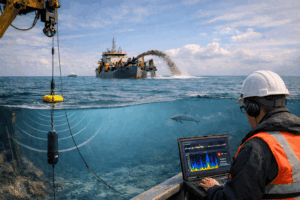
The evolution toward connected systems addresses these limitations through integration of Internet of Things (IoT) technologies, satellite communication, and emerging 5G offshore connectivity. Modern smart platforms operate autonomously for months or years. In practice, they self-diagnose technical issues and adjust sampling rates based on detected conditions. Moreover, satellite communication enables real-time transmission from remote ocean locations previously inaccessible for continuous surveillance. Furthermore, the deployment of 5G infrastructure along busy shipping lanes and offshore installations promises high-bandwidth connectivity for marine data. This infrastructure, in turn, supports video, acoustic recordings, and other information-intensive applications.
Integrated multi-parameter sensor suites
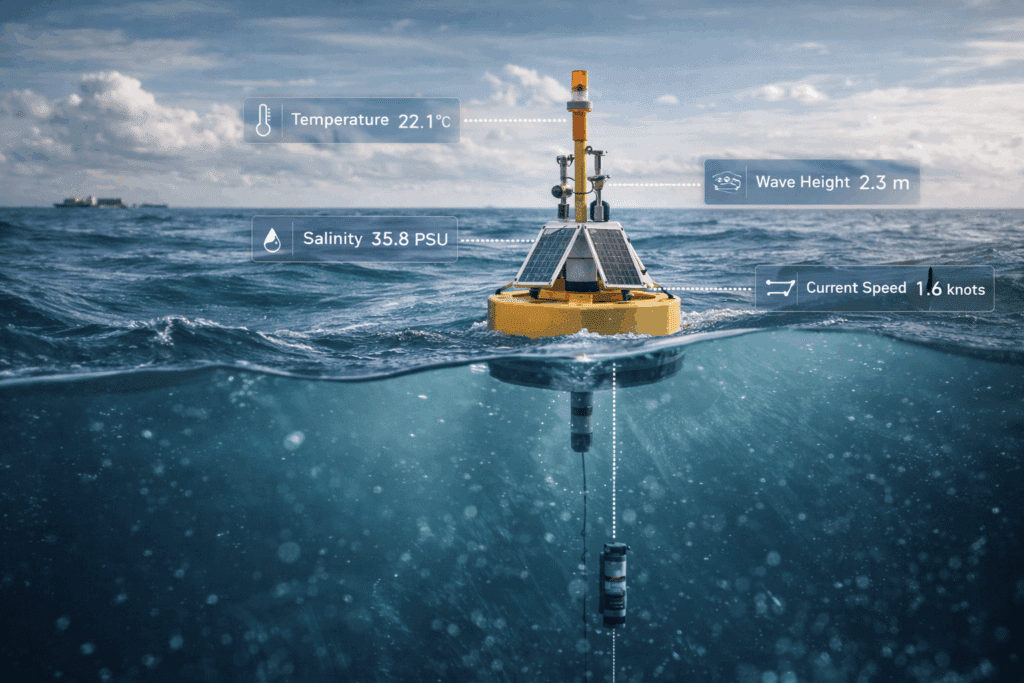
Smart platforms incorporate multi-parameter instruments measuring oceanographic, meteorological, and environmental variables simultaneously. Moreover, solar panels and efficient electronics enable extended deployments without battery replacement. Advanced instruments detect subtle changes in temperature, salinity, current velocity, and acoustic properties of the ocean. Information processing occurs both onboard through edge computing and in cloud-based platforms enabling sophisticated analysis of the collected data.
Gains in precision, continuity, and resilience
The gains in precision, continuity, and resilience transform observation from snapshot measurements to continuous time series of ocean data. These reveal temporal dynamics impossible to detect through sparse sampling. Consequently, high-frequency collection captures tidal variations and episodic events affecting maritime operations and ecosystem processes.
Autonomous operation in extreme conditions also provides vital data during hurricanes, winter storms, and other periods when human-crewed platforms must seek shelter.
Inside the technology: IoT, energy, and data transmission
Next-generation instruments enable measurements previously impossible for autonomous deployment in the marine environment.
Advanced sensing capabilities
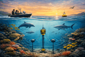
Passive acoustic monitoring systems record underwater soundscapes. They detect marine mammal vocalizations, vessel noise, and seismic activity, providing crucial data on various species. Likewise, optical instruments measure water clarity and chlorophyll concentration. Biogeochemical sensors quantify dissolved oxygen, pH, and carbon dioxide—critical parameters for ocean acidification research and ecosystem health assessment. This is essential data for understanding the ocean.
Diverse data transmission methods
Transmission employs diverse technologies optimized for different requirements and environments. For example, LoRa connectivity provides low-power communication suitable for simple information, enabling coastal surveillance. Meanwhile, Iridium satellite communication offers global coverage, supporting moderate data rates for processed observations from the open ocean.
Similarly, 5G maritime links promise high-bandwidth connectivity near ports and offshore installations. They enable video streaming and other information-intensive applications. Edge computing, in turn, processes information onboard, extracting key parameters and identifying anomalies.
Protecting data integrity and security
The Pacific Marine Environmental Laboratory deployed a fleet of autonomous surface vehicles across the tropical Pacific. These platforms measure temperature, salinity, pCO₂, and acoustic properties continuously. Solar power and efficient electronics enable six-month deployments. Consequently, information transmitted via Iridium satellite provides near-real-time observations, improving El Niño forecasting and carbon cycle research. This marine data is invaluable.

Case of Ørsted's monitoring networks
Maritime safety benefits directly from real-time ocean observation. Wave height measurements enable vessel routing that avoids dangerous conditions. In addition, current velocity information improves navigation accuracy. Real-time weather observations from offshore platforms enhance storm tracking, providing advance notice so vessels can modify routes. Likewise, drift detection tools identify pollution releases, enabling rapid response.
Applications across the maritime sector
Ørsted, the world’s largest offshore wind developer, deployed extensive surveillance infrastructure. Specifically, floating LiDAR platforms measure wind profiles. They provide information validating wind resource assessments. In addition, wave measurement devices characterize sea states affecting foundation design and vessel operations. Integration of real-time information with operational decision support tools consequently reduced weather-related delays by 15%.
The power of data: turning raw ocean metrics into insights
Raw ocean information requires processing, quality control, and analysis before yielding actionable intelligence. Automated algorithms remove outliers. Calibration procedures ensure measurement accuracy. Moreover, information fusion combines observations from multiple sources, creating comprehensive characterizations. Machine learning applications extract patterns and predictive capability from historical data.
For instance, neural models trained on years of wave information predict storm severity with greater accuracy than traditional models alone. In addition, anomaly detection algorithms identify unusual conditions, triggering alerts for human review. Classification tools distinguish vessel types from acoustic signatures, supporting maritime domain awareness and fisheries enforcement for different species.
Sinay’s integrated ocean intelligence platform
Sinay integrates multi-instrument information into comprehensive metocean analytics platforms. These, in turn, enable visualization and real-time interpretation of ocean conditions. Our platforms ingest observations from proprietary and third-party instruments, satellite information, and numerical model outputs, creating unified views of marine environments. Interactive dashboards enable operators to explore spatial and temporal patterns, overlaying environmental details with operational information.
Passive acoustic solutions specifically address underwater noise assessment and marine mammal protection. For a continuous recording of soundscapes, we deploy hydrophone arrays. Automated detection algorithms identify vocalizations from various marine species, vessel noise, and industrial sounds. Furthermore, the platform correlates acoustic information with AIS vessel tracking. Real-time alerts consequently notify operators when protected species are detected in operational areas, enabling mitigation measures.
Democratizing access with the Mobyo platform
Through our Mobyo platform, we democratize access to this kind of technology. Modular platform designs accommodate diverse instrument configurations. Integrated communication and power management simplify deployment. Moreover, cloud-based management provides stakeholders with secure access to observational data alongside context from regional surveillance infrastructure.
A European offshore wind operator implemented our integrated solution. The platform combined metocean platforms, passive acoustic monitoring, and environmental instruments. In addition, machine learning models trained on historical information predict weather windows for marine operations with 85% accuracy. Acoustic surveillance detected the presence of sensitive species, triggering construction pauses as required by permits. These measures ensure regulatory compliance. Consequently, the transformation from raw measurements to decision support reduces operational costs and enhances understanding of marine phenomena.
Predictive models enable proactive rather than reactive responses to changing conditions. Integration across information types also reveals relationships invisible when viewing single parameters.
Toward an intelligent ocean: collaboration and future outlook
Creating comprehensive ocean observing capabilities requires cooperation between research institutions, industry, and government authorities.
The importance of collaboration and standardization
Sharing agreements enable researchers to access industry-collected observations while operators benefit from scientific expertise. Moreover, standardization initiatives, including the Ocean Best Practices System, establish protocols ensuring quality and compatibility. Likewise, the Marine Data Alliance promotes interoperability between observing platforms, enabling seamless integration of observations.
The promise of emerging technologies
Emerging tech promises further transformation of surveillance capabilities. For example, bio-inspired instruments mimic the sensory abilities of certain species. In addition, embedded neural models enable sophisticated processing onboard. Digital ocean twins – virtual replicas of marine environments continuously updated with real observations – thus enable scenario testing and predictive simulation.
Vision for a digital ocean twin
The European Union’s Digital Ocean Twin initiative exemplifies a vision for integrated intelligence. Specifically, this ambitious program aims to create high-resolution models of European seas continuously assimilated with observations from satellites, autonomous platforms, and interconnected platforms. The digital twin will consequently support applications ranging from weather forecasting and maritime safety to ecosystem management and offshore optimization. However, success requires sustained investment in observing infrastructure and analytical capabilities.
FAQ
Data integrity ensures that information remains accurate, complete, and unaltered throughout its lifecycle. It is essential for reliable decision-making, regulatory compliance, and maintaining trust in digital systems.
Common risks include unauthorized access, data breaches, transmission errors, system failures, and inconsistent data sources, all of which can compromise data reliability and confidentiality.
Organizations can protect data by implementing access controls, encryption, audit trails, data validation mechanisms, and continuous monitoring to detect anomalies and prevent unauthorized changes.
Maritime Applications