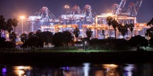

Imagine knowing the exact location and status of every ship in a fleet at any moment, ensuring their safe navigation through even the most treacherous waters. By analyzing real-time and historical data, potential delays can be predicted, routes optimized, and operational efficiency enhanced, transforming how maritime logistics are managed. That’s why vessel tracking is crucial in the maritime industry for maintaining safety, improving productivity, and ensuring the reliability of marine operations. This article explores the evolution of maritime technology, the significance of data in marine operations, emerging trends, and innovation in vessel tracking.
Evolution of Maritime Technology
Vessel tracking consists of checking a ship’s current location, anytime and anywhere in the world. Important for stakeholders in sea transport, including shippers, importers, shipping lines, and port authorities, this information aids in preparing documentation, managing operations, ensuring security, monitoring fleet performance, and facilitating communication. The maritime industry has undergone a significant transformation over the centuries, driven by technological advancements. From the early days of celestial navigation and manual logbooks to the introduction of GPS and AIS, these innovations have revolutionized tracking and management systems.
Historical Overview
In ancient times, vessel tracking was rudimentary, relying on visual sightings, celestial navigation, and rudimentary maps. Mariners used the stars, sun, and landmarks to chart their courses, while logbooks were meticulously kept to record positions and movements. These methods, though innovative for their time, were prone to errors and often led to perilous journeys.
Introduction of GPS and AIS
The advent of Global Positioning System (GPS) technology revolutionized navigation by providing precise, real-time location data, significantly improving the accuracy and safety of sea travel. Further advancement came with the introduction of the Automatic Identification System (AIS), which enabled ships to automatically broadcast their position, course, speed, and other vital information. This innovation not only enhanced navigational safety but also allowed for better traffic management and surveillance, marking a significant leap forward in marine technology.
Technological Milestones
Today, over 90% of the world’s trade is carried by sea, making accurate surveillance essential for safety. Several groundbreaking technologies have revolutionized navigation, enabling instantaneous tracing of ships globally. Among these, the development of satellite-based surveillance, as well as advancements in radar and sonar technologies, stand out as particularly remarkable.
Satellite-Based Tracking: This technology has revolutionized maritime navigation by allowing for real-time oversight anywhere in the world. The Global Maritime Distress and Safety System (GMDSS) and Long-Range Identification and Tracking (LRIT) rely on satellite technology to enhance safety and security in the marine sector.
Radar and Sonar Technologies: Radar systems, which emit radio waves to detect objects, have become essential tools for collision avoidance, navigation in poor visibility, and oversight of coastal and port areas. Modern radar systems are highly sophisticated, offering features such as automatic target tracking and integration with other navigational frameworks. Similarly, sonar technology, which uses sound waves to detect underwater objects, has improved significantly.
The Importance of Data in Maritime Operations
With over 50,000 ships transmitting data through AIS and GPS systems, the maritime industry generates vast amounts of information daily. This enables surveillance, predictive maintenance, and optimized route planning, enhancing operational performance.
Data Collection Methods
The maritime industry relies on various sources for data collection, including satellite communications and radar systems. Satellite data offers global coverage, even in remote areas, while radar systems enhance situational awareness by detecting and monitoring in real-time, particularly in coastal and congested areas. Integrating and analyzing information from multiple sources is crucial for comprehensive situational awareness. Advanced software platforms and algorithms aggregate data from AIS, satellites, and radar, providing a unified view of maritime traffic. Machine learning and big data analytics are employed to identify patterns, predict potential issues, and support decision-making processes.
Data-Driven Decision-Making
Immediate information allows for optimized route planning, reducing fuel consumption and transit times. Predictive analytics enable proactive maintenance, minimizing downtime and repair costs. Numerous strategies are transforming maritime logistics. For example, voyage optimization tools use real-time weather and sea condition data to suggest the most efficient routes. Predictive maintenance systems analyze sensor data to forecast equipment failures before they occur, allowing interventions. Additionally, port management networks utilize data to coordinate ship arrivals, reduce congestion, and enhance turnaround times, leading to more reliable logistics operations.
Role in Regulatory Compliance
Data is crucial for ensuring compliance with international maritime laws and regulations. Tracing movements, cargo details, and crew information through data collection ensures compliance with safety standards, security protocols, and regulations, thereby reducing the risk of fines and legal penalties. The International Maritime Organization (IMO) relies on accurate information to ensure adherence to its rules and regulations.
How does data help in monitoring environmental impacts?
Tracking emissions, oil spills, and other pollutants through data enables effective responses to environmental incidents. MARPOL, formally known as the International Convention for the Prevention of Pollution from Ships, is a comprehensive international treaty designed to minimize pollution of the oceans and seas, including dumping, oil, and exhaust pollution. Adopted by the International Maritime Organization (IMO) in 1973 and modified by the Protocol of 1978, MARPOL addresses various types of pollution from ships and sets strict standards for the discharge of pollutants, helping the maritime industry reduce its ecological footprint.

Trends in Vessel Tracking
With the integration of advanced satellite networks, artificial intelligence, and information, surveillance has become more accurate and efficient than ever before. This transformation is paving the way for a future where marine operations are more transparent, resilient, and responsive to the dynamic challenges of global trade.
Emerging Technologies
Artificial Intelligence (AI) and Machine Learning: These technologies analyze vast amounts of data from multiple sources to predict ship movements, optimize routes, and enhance decision-making. AI can detect patterns and immediate anomalies, improving the accuracy and reliability of ships.
Internet of Things (IoT): The devices on vessels collect and transmit data on various parameters such as fuel consumption, engine performance, and cargo conditions. This provides deeper insights into operational efficiency and helps in preventive maintenance.
Blockchain Technology: Blockchain is being explored to enhance transparency and security in maritime logistics. It can create an immutable record of cargo details and compliance with regulations, reducing the risk of fraud and improving traceability.
Maritime Security and Cybersecurity
Enhanced Cybersecurity Measures: As tracking platforms become more sophisticated and interconnected, they are increasingly vulnerable to cyberattacks. The industry is investing in robust cybersecurity measures to protect data integrity and prevent unauthorized access.
Automated Identification System (AIS) Security: While AIS is crucial for maritime surveillance, it is also susceptible to spoofing and jamming. Advances in AIS security are being developed to authenticate signals and prevent tampering.
Maritime Domain Awareness (MDA): The innovation integrates data from various sources, including AIS, radar, and satellites, to provide a comprehensive picture of maritime activities. They enhance situational awareness and help detect and respond to potential security threats.
Sinay's Cutting-Edge Maritime Surveillance Tools
Tracking a vessel’s real-time location and details is quick and simple using our innovative solution, which aggregates data from all Vessel Monitoring Systems (VMS). Users can search using the ship’s name or MMSI/IMO number to obtain accurate information on any ship. We offer a suite of APIs designed to enhance sustainability in ocean freight. Integrating surveillance through APIs simplifies processes, providing seamless access to critical data. Accessible through our developer portal, integrate our APIs within 5 minutes:
Container Tracking API: Integrate container tracking information, including location, delivery status, and estimated time of arrival (ETA), seamlessly into your systems.
Port Congestion API: Access immediate status updates on port congestion worldwide, filter by ship type and characteristics, and compare congestion levels against global averages.
ETA Calculator API: Utilize AI and machine learning algorithms to generate automated ETA predictions for any watercraft to any port globally, leveraging historical insights for high accuracy.
CO2 API: Monitor carbon dioxide emissions per Twenty-foot Equivalent Unit (TEU) for any sea voyage, enabling proactive management and compliance with emissions regulations.
Noise API: Track Sound Exposure Levels (SEL) for various boat types and journeys worldwide, comparing against industry standards from Lloyds and Bureau Veritas.
Ports and Vessels API: Easily find port UNLOCODEs or identifiers corresponding to known names, facilitating seamless integration with other Sinay APIs and enhancing the user experience.
How Is Innovation Driving the Future of Vessel Tracking?
Innovation in cargo tracking is rapidly evolving, driven by advancements in technology and the imperative for sustainability in maritime operations.
Sustainable Solutions
The integration of eco-friendly innovation marks a significant shift towards sustainability in the maritime sector. Innovations include the use of renewable energy sources for powering tracking devices and minimizing environmental impact while enhancing operational efficiency. This integration not only meets regulatory requirements but also supports global efforts to reduce carbon footprints and promote sustainable practices across the industry. For example, solar-powered tracking systems and energy-efficient sensors are becoming more prevalent, helping to reduce reliance on fossil fuels. By adopting these innovations, the maritime sector can achieve a balance between operational demands and environmental responsibility, ensuring a greener future for global shipping.
Real-Time Tracking
Technologies provide instant access to vessel positions, speeds, and environmental conditions, facilitating proactive decision-making and improving response times during emergencies. Innovations in this field are making surveillance more accessible through user-friendly interfaces, mobile applications, and integration with other maritime frameworks, ensuring seamless information flow across stakeholders. For instance, the Vessel Traffic Mobile System (VTMS) is a technology designed to monitor and manage vessel traffic, ensuring safe and efficient navigation in congested waterways. The outlook for the VTMS market is optimistic, with an anticipated growth rate of 11.7% from 2024 to 2031.
Future Prospects
Looking ahead, surveillance technology is poised for continuous innovation. Predictions indicate further advancements in AI and machine learning algorithms for predictive analytics, improving accuracy in ETA calculations, and optimizing route planning. The future will likely see increased integration of IoT devices and satellite communications, enhancing coverage and reliability in remote maritime regions. Continuous innovation will shape the industry by enabling smarter fleet management, reducing operational costs, and supporting sustainable growth strategies in global maritime trade.
A new era is calling us to embrace innovation in marine surveillance, driving safer navigation, enhanced efficiency, and heightened transparency in shipping operations. By integrating sustainability into technology, we not only meet regulatory demands but also pioneer eco-friendly practices. As advancements in AI, IoT, and analytics propel us forward, stakeholders will benefit from streamlined operations, reduced environmental impact, and improved global connectivity. This transformative journey promises a future where tracking not only ensures safety but also fosters a sustainable and resilient maritime industry for generations to come.
FAQs about trends in Vessel tracking
Several key trends are shaping the future of vessel tracking:
Enhanced Satellite Technology: The use of more advanced satellites with higher resolution and real-time data transmission capabilities is significantly improving vessel tracking accuracy and coverage, especially in remote ocean areas.
Artificial Intelligence and Machine Learning: AI and ML are being used to predict vessel movements, optimize routes, and improve safety by identifying potential risks and anomalies in vessel behavior.
Integration with IoT: The Internet of Things (IoT) enables vessels to communicate with each other and with shore-based systems, providing comprehensive tracking data and operational insights.
Blockchain Technology: Blockchain is being explored to enhance security and transparency in the tracking and logging of vessel movements, helping to prevent fraud and improve data reliability.
Artificial intelligence (AI) is enhancing vessel tracking systems in several ways:
Predictive Analytics: AI algorithms analyze historical data to predict future vessel movements and potential delays, enabling better planning and decision-making.
Anomaly Detection: AI helps identify unusual patterns or behaviors in vessel movements, which could indicate safety issues, security threats, or non-compliance with regulations.
Route Optimization: AI-powered tools optimize routes based on various factors such as weather conditions, traffic congestion, and fuel efficiency, reducing costs and improving delivery times.
Automation: AI automates routine tracking tasks, freeing up human operators to focus on more complex and strategic activities, and reducing the likelihood of human error.
The Internet of Things (IoT) plays a crucial role in the future of vessel tracking by:
Real-time Data Collection: IoT devices installed on vessels collect real-time data on location, speed, weather conditions, and equipment status, providing a comprehensive view of vessel operations.
Enhanced Connectivity: IoT enables seamless communication between vessels, ports, and shore-based control centers, facilitating better coordination and information sharing.
Predictive Maintenance: IoT sensors monitor the health of vessel equipment, predicting maintenance needs before failures occur, reducing downtime, and improving operational efficiency.
Safety and Compliance: IoT helps ensure vessels comply with safety regulations by monitoring compliance in real-time and alerting operators to any deviations or potential hazards.
Blockchain technology has the potential to revolutionize vessel tracking by:
Enhanced Security: Blockchain provides a secure, tamper-proof record of vessel movements and transactions, reducing the risk of data breaches and fraud.
Transparency: The decentralized nature of blockchain ensures transparency in the tracking data, as all stakeholders have access to the same information, which can be independently verified.
Streamlined Operations: Blockchain can streamline administrative processes, such as customs clearance and cargo documentation, by providing a single, immutable record, reducing paperwork and delays.
Trust and Accountability: Blockchain fosters trust among all parties involved in vessel tracking by ensuring data integrity and accountability, as every transaction is recorded and cannot be altered retroactively.